
| Chichonal Volcano Risk Map Released The News | |
| go to original April 11, 2012 |
 |
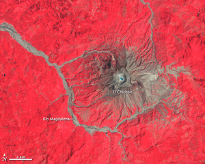 |
Researchers from the National Autonomous University of Mexico’s (UNAM) Geophysics Institute presented the government of Chiapas with a risk map for the Chichonal volcano on April 4, the fourth volcano risk map the Institute has created.
José Francisco Valdez Galicia, director of the Geophysics Institute, said that the risk map is, “meant to better inform the regional government of the risk to which it is exposed, so that it can create better plans.”
The presentation of the map was part of the 30-year anniversary ceremonies of the Chichonal volcano’s eruption in the municipality of Francisco León. Valdez Galicia said that the map will help both governmental agencies and the people of the region to plan meeting points, shelters, and evacuation routes.
Governor Juan Sabines Guerrero said that the lesson of the tragedy 30 years ago is that prevention is the best way to save lives.
When he was a boy, Sabines Guerrero said, he went with his father – then-Governor Juan Sabines Gutiérrez – to the disaster area and witnessed the Mexican Army’s emergency-management efforts. Accompanied by local residents, Sabines Guerrero unveiled a bust of the municipal president during the eruption, Rodimiro Ramírez Estrada, who died as he helped save the lives of the people of Francisco León.
We invite you to add your charity or supporting organizations' news stories and coming events to PVAngels so we can share them with the world. Do it now!
Celebrate a Healthy Lifestyle
 From activities like hiking, swimming, bike riding and yoga, to restaurants offering healthy menus, Vallarta-Nayarit is the ideal place to continue - or start - your healthy lifestyle routine.
 Banderas Bay offers 34 miles of incomparable coastline in the states of Jalisco and Nayarit, and home to Puerto Vallarta and Riviera Nayarit's many great destinations.