
| Google Maps to Add Panoramic Views of Mayan Ruins Associated Press | |
| go to original August 16, 2012 |
 |
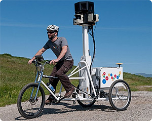 |
| Going beyond just mapping streets, Google sends bikes on hiking trails, college campuses and other places that cars can't (or shouldn't) drive. (Google) |
Google is adding interactive images of dozens of pre-Hispanic ruins to the “Street View” feature on its Google Maps website.
Google Mexico and Mexico’s National Institute of Anthropology and History announced Thursday that 30 sites have been added to Street View, and dozens more will be coming online this year. The eventual goal is 90 sites.
The feature allows users to click on map locations to obtain 360-degree, interactive images composed of millions of photos taken at street level by specially equipped vehicles. Google uses a special, three-wheeled bicycle to generate images of the Mexican sites, many of which don’t have paved areas.
The sites already online include Chichen Itza, Teotihuacan and Monte Alban. Check it out at Google Maps.
We invite you to add your charity or supporting organizations' news stories and coming events to PVAngels so we can share them with the world. Do it now!
Celebrate a Healthy Lifestyle
 From activities like hiking, swimming, bike riding and yoga, to restaurants offering healthy menus, Vallarta-Nayarit is the ideal place to continue - or start - your healthy lifestyle routine.
 Banderas Bay offers 34 miles of incomparable coastline in the states of Jalisco and Nayarit, and home to Puerto Vallarta and Riviera Nayarit's many great destinations.