
| Google Tracks Hellish Wildfire Season Curt Hopkins - Ars Technica | |
| go to original July 4, 2012 |
 |
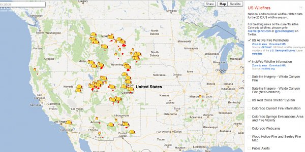
Google has created the 2012 U.S. Wildfire Crisis Map to dynamically track the four dozen wildfires blazing across the United States, mostly in the West.
The map, built on its Crisis Response platform, is tracking about 50 fires, including the 100,000-acres Clay complex in Utah and the dangerous Waldo Canyon fire that is threatening the city of Colorado Springs. The map tracks the fires themselves, including their extent and information on suppression efforts, evacuation status and the locations of shelters.
Google has pulled together data on fire perimeters from the U.S. Geological Survey and InciWeb, shelter information from the Red Cross, satellite info from DigitalGlobe, and fire weather information from NOAA's Storm Prediction Center. Local-level data has been drawn from the State of Colorado Division of Emergency Management, Utah Division of Emergency Management and other sources. This information has been plotted in layers across Google Maps and Google Earth.
The interface allows users to "turn on and off the layers of information" using a checkbox in the right-side panel. A "Share" button up top allows you to capture the URL or the embed code. A KML (keyhole markup language) file of the Waldo fire allows you to view that most dangerous of fires in great detail in Google Earth.
On the LatLong Blog, Pete Giencke of Google's Crisis Response Team, encourages users to provide the team with data requests, to enrich the mapping possibilities during the fire season.
Read more at Ars Technica
Curt Hopkins writes for Ars Technica about the intersection of culture and technology, including the democratization of information, spaceships, robots, the theatre, archaeology, achives and free speech.
We invite you to add your charity or supporting organizations' news stories and coming events to PVAngels so we can share them with the world. Do it now!
Celebrate a Healthy Lifestyle
 From activities like hiking, swimming, bike riding and yoga, to restaurants offering healthy menus, Vallarta-Nayarit is the ideal place to continue - or start - your healthy lifestyle routine.
 Banderas Bay offers 34 miles of incomparable coastline in the states of Jalisco and Nayarit, and home to Puerto Vallarta and Riviera Nayarit's many great destinations.